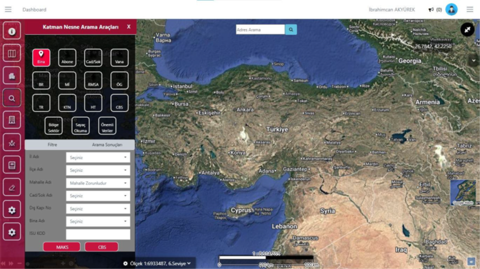
Layer and Object Search Tools
This screen enables all assets in the gas distribution infrastructure (buildings, subscribers, valves, pipelines, service boxes, meters, and other critical elements) to be queried in detail on the map.



Natural Gas Infrastructure GIS
A solution that manages natural gas network assets and field operations on a single map-based platform.
OverviewExplore
Map, Format Support, Detailed Reports, Integration Compatibility, and Regulatory Compliance are managed within the same corporate structure.
Overview
Natural Gas Infrastructure GIS is an integrated infrastructure management system that enables natural gas distribution companies to manage all their network assets, maintenance and repair processes, fault detection, and field operations on a map-based platform.
Capabilities
Core Competencies
A solution that manages natural gas network assets and field operations on a single map-based platform.
Go to OverviewThis screen enables all assets in the gas distribution infrastructure (buildings, subscribers, valves, pipelines, service boxes, meters, and other critical elements) to be queried in detail on the map.
This screen is the center where all operational and field processes are initiated. From here, the user can select many operation types such as building connection, customer declaration, and station and regulator operations.
This screen is used to quickly find all subscribers in the field. By account number, contract number, Turkish ID, meter, or consumption point information.
This screen is used to quickly find all valve assets in the field. By entering the province, district, neighborhood, road information, or GIS asset ID.
This screen shows all GIS and subscription data of the selected building in a single panel. Along with address components such as province, district, neighborhood, street, and door number.
This screen is used to quickly view and update the Spatial Address Registration System data of the selected building.
Capability Cards
The main modules from the documentation were organized into corporate summary cards within the existing page structure.
This screen enables all assets in the gas distribution infrastructure (buildings, subscribers, valves, pipelines, service boxes, meters, and other critical elements) to be queried in detail on the map.
This screen is the center where all operational and field processes are initiated. From here, the user can select many operation types such as building connection, customer declaration, and station and regulator operations.
This screen is used to quickly find all subscribers in the field, by account number, contract number, Turkish ID, meter, or consumption point information.
The Valve Search Tool area lets you track, control, and manage the related process from a single screen in line with corporate workflows.
The Building Information Card area lets you track, control, and manage the related process from a single screen in line with corporate workflows.
The Building Information Card – Spatial Address Registration System Tab area lets you track, control, and manage the related process from a single screen in line with corporate workflows.
The Building Information Card - Line and Equipment Information Tab area lets you track, control, and manage the related process from a single screen in line with corporate workflows.
The Map area lets you track, control, and manage the related process from a single screen in line with corporate workflows.
Resources
Access presentation and promotional content about Natural Gas Infrastructure GIS from this area.
Product Tour
This screen enables all assets in the gas distribution infrastructure (buildings, subscribers, valves, pipelines, service boxes, meters, and other critical elements) to be queried in detail on the map.
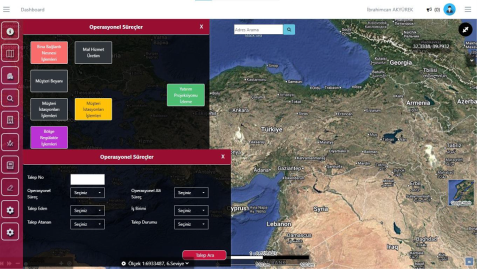
This screen is the center where all operational and field processes are initiated. From here, the user can select many operation types such as building connection, customer declaration, and station and regulator operations, and open the relevant process.
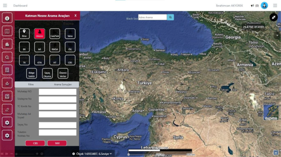
This screen is used to quickly find all subscribers in the field. By entering the account number, contract number, Turkish ID, meter, or consumption point information, the subscriber's GIS or civil registry data can be accessed directly.
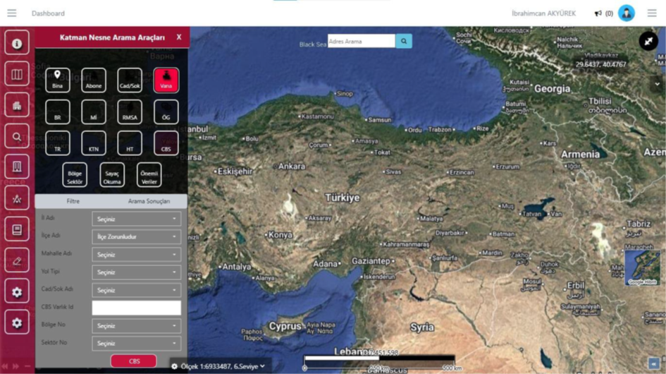
This screen is used to quickly find all valve assets in the field. By entering the province, district, neighborhood, road information, or GIS asset ID, the relevant valve is instantly marked on the map.
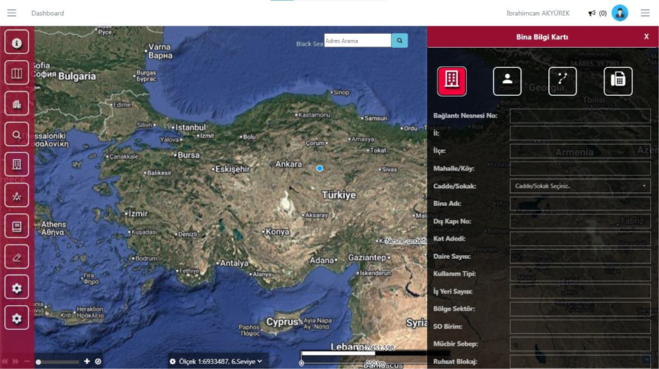
This screen shows all GIS and subscription data of the selected building in a single panel. Along with address components such as province, district, neighborhood, street, and door number, details such as building name, floor information, usage type, number of workplaces, region sector, and service area can be viewed.
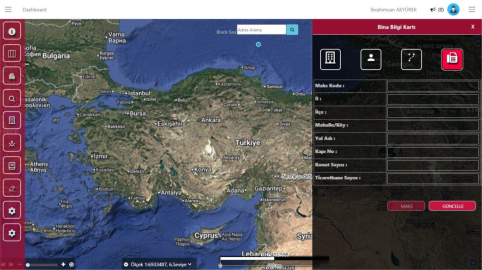
This screen is used to quickly view and update the Spatial Address Registration System data of the selected building. Official address components such as province, district, neighborhood, road name, door number, and the number of residences and commercial premises can be edited in this tab.
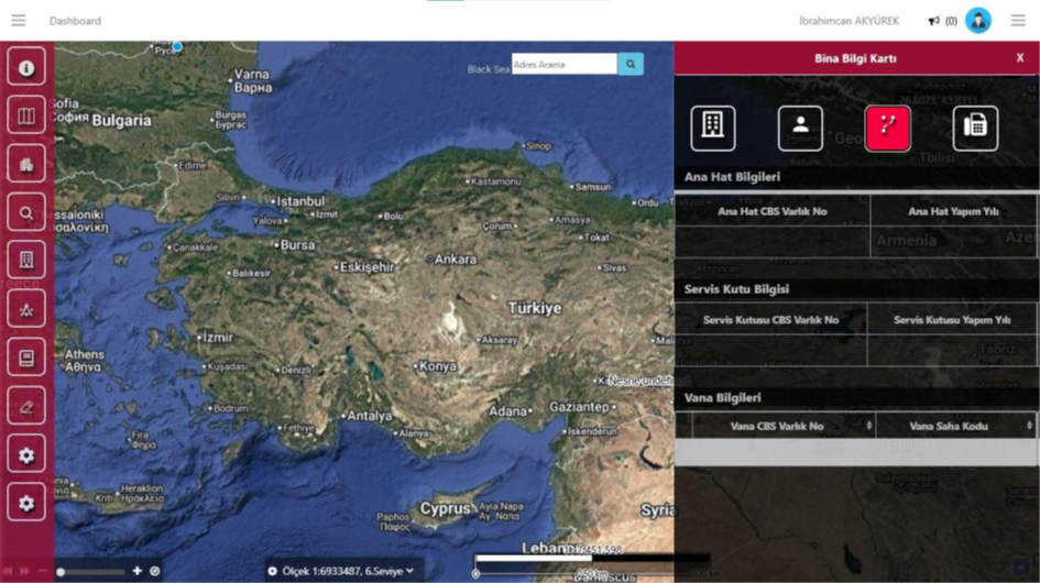
This tab shows all field equipment connected to the building, such as the main line, service box, and valve, on a single screen.
It displays natural gas lines, service boxes, valve chambers, regulators, and connection points spatially on a GIS-based map; it ensures a full match between the field and the office.
It supports SHP, GML, GeoJSON, WFS/WMS, and SQL-based data formats; infrastructure network layers can be imported into the system in line with standards.
Leak detections, gas on-off operations, maintenance activities, fault records, and all information on network elements can be reported.
It works fully compatibly with Spatial Address Registration System, Land Registry and Cadastre Information System, Enterprise Resource Planning, SCADA, IoT meter systems, e-signature, and Electronic Document Management System integrations.
It is fully compliant with the Energy Market Regulatory Authority distribution network standards, the GIS regulation, and the relevant infrastructure regulations.
FAQ
The product's core use cases and corporate contribution are summarized here.
Get in TouchNatural Gas Infrastructure GIS
OdakGaz is an integrated infrastructure management system that enables natural gas distribution companies to manage all their network assets, maintenance and repair processes, fault detection, and field operations on a map-based platform.